Tag Archives: world
February 6, 2018

The Queen’s Walkabout

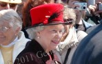
Queen Elizabeth II  greeted  the crowds, shaking hands and patting babies on her walkabout in the Channel Islands off the coast of France in 2005.   Photo by Gene Korte 


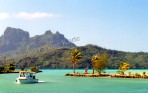
Guernsey, Jersey and Sark are the names of three of the four main Channel Islands that pledge allegiance to the Union Jack while located 20 miles from France. Isolated from England by more than eighty miles of the often rough waters of the English Channel, these islands have always been a place unto themselves, and in many ways they still are. The Channel Islands have their own currency and passports, for example, and on the island of Jersey, some court trials are conducted only in Norman French, not the Queen’s English.

But British they are. On the 60th anniversary of the liberation of the Channel Islands in 1945, the special guests of honor were Queen Elizabeth II and Prince Philip.  Liberation anniversaries are of special interest here, as these islands were the only part of Great Britain that was occupied by the Germans during World War II.

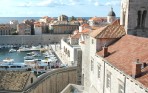
The first ceremony of the day on Guernsey was an appropriately solemn affair in a meeting hall in St. Peter Port, this island’s capital city. From our seats in the balcony, however, the gathering looked like a glorious spring flower display, as every woman there was wearing a big, gorgeous hat.

At the parade, vintage military vehicles in tiptop shape, shipped in from England on ferryboats, came in a cavalcade that went on for hours. Soldiers in 1940s uniforms marched, and a man who was a ringer for Winston Churchill waved to the crowd from his wartime Jeep. There were several flyovers, including the sleek British Red Arrows with 12 planes in formation. Another grouping featured a Lancaster, Hurricane and Spitfire, all British World War II-era planes.

Before the royal couple left Guernsey, an island with a population of about 65,000, Queen Elizabeth strolled by the parade route in her traditional walkabout, greeting the crowds, shaking hands and patting babies. That afternoon she flew to Jersey for that island’s even more lavish festivities.

Known for its dramatic coastline, its pirate past and feudal present, our next day’s destination, Sark, is all of three miles long and a mile and a half wide. The 600 locals, who are mostly Brits and known as Sarkees, have a real lord of the manor and their own code of medieval laws that date back centuries. In 1565 the island was divided into 40 pieces of land, and that division remains intact today. Sark is self-governed, self-financed and has its own legislature.

After arriving at the harbor, we boarded the so-called toast rack, a tracker-pulled, open-sided bus that took us to the top of a steep hill where a few shops were scattered along a narrow road. Cars are not permitted on this island, so visitors and locals alike get around by foot, bicycle or horse-drawn cart, though a tractor hauls visitors’ luggage to their accommodations.

To get to the island’s Stocks Hotel, our home for the night, we walked through town, made a left at the visitor’s center, admired the big house on the lane, and then turned at the little sign by the meadow. Once there we followed the footpath by a sheep pasture until we arrived at the hotel that was originally built as a farmhouse in 1741. Later at dinner, I asked for the seafood that guests ordered the most. It turned out to be skate, a cousin to the manta ray, a mild-tasting flat fish as big as the sizable platter it came on.

While on Sark, we met local historian, Richard Dewe, who has been collecting World War II occupation memorabilia for decades. This photo, that document, it’s now quite a compilation. The only local who died during those five years, according to his records, was a young girl who stepped on a land mine. Although there were no battles here, the last couple of years of the war had food shortages for all, including the occupying Germans. What helped the Channel Islanders toward the end, according to Dewe, were the food packages from the Red Cross ship, Vega. Now, whenever an international disaster occurs that requires the work of the Red Cross, the islanders dig deep into their pockets to contribute in memory of their own time of need.

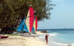
Jersey, yet another ferry ride away, has 20 miles of sandy beaches and a moderate climate. The largest of the Channel Islands, it’s also the one closest to France. In our few days on this cosmopolitan island of about 90,000 citizens, we saw newborn Jersey cows, country lanes, colorful gardens, an experimental orchid farm, even a family of gorillas at the zoo.

This island also has the most to see from the days of the German occupation nearly 70 years ago. The Jersey War Tunnels, known as Ho8, are one of the most popular visitor sites for all nationalities. Among its exhibits is Captive Island that shows how the occupation affected the locals. Designed as a bombproof barracks, the Jersey Tunnels eventually housed an underground hospital.

For a look at this part of the world during World War II, see “The Guernsey Literary and Potato Peel Pie Society” by Mary Ann Shaffer and Annie Barrows (Dial Press 2009).

ON THE CHANNEL ISLANDS

GUERNSEY:

Guernsey Tourism, http://www.visitguernsey.com, enquiries@visitguernsey.com, P.O. Box 23, St. Peter Port, Guernsey, Channel Islands GY1 3AN, +44 (0) 1481 723552.

Old Government House Hotel, http://www.theoghhotel.com, P.O. Box 47, Ann’s Place, St. Peter Port, Guernsey, GY1 4AZ Channel Islands, 01481738505. The OGH is the longest established hotel in St. Peter Port and when it was an 18th-century house, it was the official residence of the governor of the Island.

JERSEY:

Jersey Tourism, http://www.jersey.co.uk, Liberation Square, St. Helier, Jersey, JE1 1BB, +44 1534 500700, fax 44 1534 500899.

Jersey War Tunnels, http://www.jerseywartunnels.com, info@jerseywartunnels.com, Les Charrieres Malorey, St. Lawrence, Jersey, JE3 1FU, Channel Islands, +44 (0) 1534 860 808.

Somerville Hotel, http://www.dolanhotels.com, Somerville@dolanhotels.com, St. Aubin, Jersey JE3 8AD, Channel Islands, +44 (0) 1534 741226.

St. Brelades Bay Hotel and restaurant, http://www.breladesbayhotel.com, info@stbreladesbayhotel.com, 01534-746141.The Eric Young Orchid Foundation, http://www.ericyoungorchidfoundation.co.uk, Victoria Village, Trinity, Jersey JE3 5HH, Channel Islands, +44 1534 861 963.

SARK:

Sark Tourism. http://www.sark.info/, e-mail: contact@sark.info, Sark, Channel Islands GY9 0SB, +44 (0) 1481 832345. There is no airport on Sark. Visitors arrive by ferry, usually from Guernsey, a trip that takes about 45 minutes.

Stocks Hotel. http://www.stocks-sark.com. Originally built as a farmhouse in 1741, it became a hotel in 1895.

Distributed by Tribune Media Services, INC. for World’s Fare Syndicate

© 2005-2018  Diana and Gene Korte

January 7, 2018

Tahitian Wonders

This view of paradise greets travelers who arrive at Bora Bora’s Motu Mute Airport.  Photo by Gene Korte


Ia ora na!

Greetings from Bora Bora — a tiny piece of heaven in the South Pacific.

The water is impossibly blue, except for those improbable shades of green, and everywhere you turn, it is — snap, snap, snap — picture postcard perfect. James Michener, author of “Tales of the South Pacific,” thought Bora Bora was the most beautiful island of all. No wonder.

Bora Bora, which lies about 150 miles northwest of Tahiti (http://www.tahiti-tourisme.com), is about five miles long and a couple of miles wide and surrounded by a barrier reef and a lagoon. Palm-covered motus, or tiny islands, form a necklace around the main island, while native hibiscus flowers spread their lush scent on the hillsides. Some visitors come to sail and swim, snorkel and dive these amazingly clear waters. While others come to sink in the perfect sand, experience the tropical beauty and channel their inner Paul Gauguin.

Here are a few reasons why this romantic island is so magical.

TI’A MOANA

Ships that sail the South Pacific stop here. Boats that travel within the borders of French Polynesia, an area bigger than Europe, stop here. And then there’s the yacht the Ti’a Moana (http://www.bora-bora-cruises.com ) that  sails in and around Bora Bora and its Society Island neighbors — Taha’a, Raiatea and Huahine.

The Ti’a Moana is a honeymooner’s dream. In fact, most of the 38 passengers on our trip were newlyweds from France and Spain. The ship offers all outside cabins, large windows and exquisite furnishing and passengers are pampered by a well traveled and trained international staff who seemed to read our minds and catered to our every want and need, providing privacy, though there were others onboard. The food on this stylish, Tahitian-owned yacht was the best French food we’d had in years. And because the yacht is so small, it was able to maneuver into many a remote beach.

OVERWATER BUNGALOWS

The first luxury resort bungalow on stilts over the Bora Bora Lagoon appeared years ago and now there are about a dozen upmarket resorts here with this feature.  These overwater bungalows can be found in other parts of the South Pacific, but if you’ve seen photos of these unusual places, chances are they were taken in Bora Bora. Although couples show up at these resorts, they offer special family packages as well.

We stayed in an overwater bungalow at the Bora Bora Lagoon Resort  & Spa located on Motu Toopua. It’s 10 minutes from the Bora Bora airport by skiff and a few minutes across the water from Vaitape, Bora Bora’s main town.

Although there were people around at the reception desk and in the restaurant, once you’re in your bungalow, it’s only you and the tropics. We had our own private steps into the warm water of the lagoon and when daylight faded, we could see into the water through our Tahitian television, that is, our glass-top coffee table that provided illuminated views of the fish. This resort is a place where you can enjoy views of Bora Bora’s classic mountain peak, Otemanu, and treetop massages, along with a full range of spa and aquatic offerings.

HAWAIKI NUI VA’A

For centuries, Polynesian warriors have raced across the open waters of the South Pacific in their outriggers. In today’s version of the race, six-person teams compete over three days in October in the Hawaiki Nui Va’a, the Super Bowl of outrigger canoe races, http://www.hawaikinuivaa.pf/.

Contestants wear matching T-shirts and baseball hats and their outriggers are covered with advertising like Indy 500 cars. Despite the presence of sailing ships and powered support boats throttling in the open waters just a few feet away, the racers still move their oars in perfect harmony at about one stroke per second and switch sides simultaneously in practiced choreography. We watched the finish of one of the 72-mile races on the deck of the Ti’a Moana while it was moored in the harbor on the island of Raiatea.

HOW TO GET THERE:

Travelers come mostly by air, but also by sea. Bora Bora’s busy Motu Mute Airport — about 45 minutes by air from Tahiti — was built in 1942 by the United States during World War II and was French Polynesia’s first international airport. Tahiti is five hours by air from Easter Island and eight hours from Los Angeles.

Air Tahiti Nui (http://www.airtahitinui-usa.com) is the leading carrier to French Polynesia and has a half-dozen daily inter-island flights to Bora Bora from Fa’a’ā International Airport on the island of Tahiti. Check their website for special travel packages, including family rates, from the United States and other parts of the world.

LAN Airlines (http://www.lan.com) is the dominant airline in South America. It’s also the only airline, and has been since 1968, that flies from Easter Island to Tahiti with two round-trip flights per week. Fly this way from North America and you’ll be stopping at two of the world’s most exotic destinations.

LESS EXPENSIVE HOTEL OPTIONS:

Luxury yachts and resorts in Bora Bora are pricey, but French Polynesia has more than 100 islands. If you’re looking to travel here more economically, there are about 250 pensions or family hotels throughout the five island groups in Tahiti, https://tahititourisme.com/en-us/vacation-packages/

AVERAGE TEMPERATURE: In Bora Bora it’s 82 to 85 degrees year-round with water temperature in the low 80s.


Distributed by Tribune Media Services, INC. for World’s Fare Syndicate

© 2018  Diana and Gene Korte


October 2, 2017

Balmy Barbados

Barbados is one of the southernmost islands in the Caribbean where daytime highs average 75 to 80 degrees, and the air is cooled by constant trade winds. Photo by Gene Korte


You can imagine, of course, that the beaches are fabulous here.  You even get to choose between the pounding surf of the Atlantic on one side of the island and the gentle waters of the Caribbean on the other.

Perhaps you’ve heard that people don’t really go to this part of the world for the food. That’s not true in Barbados, the only island in the Caribbean with its own Zagat Guide.

If you’re a seafood lover, it’s worth the trip just to taste the locally caught barracuda served at Champers Restaurant and the flying fish at the Waterfront Cafe.

Once the home of a booming sugar cane industry, today this prosperous 14-by-20-mile island hosts plenty of sunbathers, but that’s not all. The other two big draws for Barbados are duty-free shopping and outstanding golf courses. One of the island’s best-kept secrets, however, is 450 years of history made visible through museums, particularly one that opened in the spring of 2008.

GOING DOWN MEMORY LANE

The Arlington House, a jewel of a museum, tells the story of Barbados through visuals, sounds and touch. Situated in an 18th-century coral stone house located in Speightstown, this museum was the home of generations of a merchant family for 200 years.

Surround-sound memories, like a movie soundtrack, and visuals of an olden-times Saturday market day fill the ground floor of this museum. The second floor shows the important role Barbados played in the slave trade. A video of two plantation ladies discussing the sugar in their tea side by side with the comments of the workers in the sugarcane field is a lesson in island economics.

Of the 30 or so island nations in the Caribbean, Barbados is the furthest east and nearly the most southern. Because of that location, hurricanes seldom come to call. Nevertheless, one of the last stops on the third floor, where an electronic pirate has a lot to say, is a display that’s not to be missed. It cleverly demonstrates the sound and fury of hurricane wind.

Barbados is also home to one of the oldest synagogues (built in 1654) in this part of the world. Located in Bridgetown, the Nidhe Israel Synagogue, with its beautiful Gothic arches, has recently been restored and houses an old cemetery on the grounds, along with a museum and a new archeological excavation site. The synagogue is open to the public daily.

GEORGE WASHINGTON SLEPT HERE

When our first president was but a teenager, he came to Barbados with his ailing half-brother Lawrence for a couple of months in 1751. Because of a lung problem, doctors recommended that Lawrence take a trip to the West Indies.

To continue reading this article, go to http://www.ihavenet.com/vacation-travel/Balmy-Barbados-Vacation-Guide-DK.html

© 2011  Diana and Gene Korte

August 1, 2016

Europe’s Sunny Adriatic Sea

Dubrovnik in Croatia on the Cote d’Azur coastline of the Adriatic is one of the best-preserved medieval walled cities in the world.       Photo by Gene Korte


The Adriatic is an inviting 500-mile-long sea with Italy on its western coastline and once isolated European countries on its eastern shores. Despite a delightful Mediterranean type climate, this region has been mostly off the American traveler’s radar until the last 15 years.

War raged in this region in the early 1990s, and before that the borders were commonly closed to the West for the 50 or so years of communist rule.  The jewel of the Adriatic, Dubrovnik in Croatia, was under constant siege for six months in 1991 by the Serbs. It was rebuilt in part with UNESCO funds and some say it is grander than ever.  Tiny Montenegro (population about 650,000) asserted its independence from Serbia and is one of the newest countries in the United Nations. Even Albania, one of the least visited countries in Europe, though still littered with hundreds of thousands of small concrete bunkers constructed in the 1980s to supposedly protect citizens from American invaders, now welcomes foreign travelers.

The Adriatic’s northernmost post is the Italian city of Venice.  Going south from there,  the Riviera-like coastline of Croatia (http://www.croatia.hr) showcases more than 1,000 islands, moored yachts and red-roofed coastal towns. Montenegro follows next with its towering mountains and bountiful beaches (http://www.visit-montenegro.com). And finally the sea reaches the colorful shores of Albania (http://www.albaniantourism.com), before the Adriatic flows into the Mediterranean.   Here are some of the finest stops along the way:

Dubrovnik in Croatia is one of the best-preserved medieval walled cities in the world. The best views are from the walls themselves – they are a mile-and-a-half in circumference – which circle the old city and date from the 13th century. During our visit, we viewed a passionate musical performance at the Dominican cloister. The Klapa Ostro Konavle group performed the traditional a capella klapa singing, famous throughout southern Croatia.

A half-hour from the Croatian port city of Sibenik, a town first settled 3,000 years ago, is the Krka National Park. Known for its waterfalls, wildlife and the terraced cascades of Skradinski Buk, I had the best ice cream of the trip here. Vanilija on a stick, bought for 50 cents from a park vender.

The small town of Trogir in Croatia, once controlled by Venice when it was an empire, is actually an island surrounded by a medieval wall with two giant gates that lead into a town of numerous small squares. It was in this town in particular that the Middle Ages seemed to be around every corner. A good example is the Cathedral of St. Lawrence. Among its timeless attributes are the 16th-century walnut choir seats and a legend of a local hero who was killed by the Venetians and carried away, but as the story goes, returned to Trogir with the help of the angels.

The most exciting moments in Montenegro after we landed at Kotor were driving on the 25 serpentine switchbacks with a speedy driver up to a small smokehouse that overlooks the fjords below. While there we were offered generous platters of the locally made prosciutto, cheese and bread along with honey wine. From this high point, we viewed the panorama of this country’s dark towering mountains, understanding the meaning of the word Montenegro–black mountains.

The 20-mile drive from the port of Durres in Albania to the capital city of Tirane was quite an eye-opener and not to be missed. Buildings are being torn down and simultaneously made new all at once with huge heaps of trash from both endeavors everywhere. While city planning and trash collecting are obviously backed up, the Albanians themselves appear enthusiastic about getting on with the 21st century. We saw young women in jeans and tank tops in Tirane walking in front of 24-hour gas stations, though neither sight was common.  This country of many contrasts also boasts outstanding Roman ruins.

We traveled for more than a week in the Adriatic as part of a longer trip that also explored the Mediterranean all the way to Portugal on Lindblad Expeditions National Geographic Endeavour (http://www.expeditions.com).  The company has exotic itineraries around the world from the Arctic to the Antarctic and owns and/or operates many small ships. All of them have experts who lecture and accompany groups on zodiac excursions.

Distributed by Tribune Media Services, INC. for World’s Fare Syndicate

© 2011-2014  Diana and Gene Korte

January 18, 2016

At the bottom of the world

November through March is the season when ships make their way down through the rough-and-tumble waters of the Drake Passage from the southern tip of South America to the northern reaches of Antarctica. It’s the ice continent’s summer.    Photo by Gene Korte


Antarctica is home to 90 percent of the world’s ice. Because of that, it’s a thrilling other-worldly place. As our ship moved along iceberg alley, bergs almost as large as small towns appeared and ranged in hues from white to blue and green. Our ship, the Endeavor, occasionally stopped to cut through ice, sounding like the largest blender ever.

Despite being the continent with the most hostile environment, last season there were 37,000 visitors to Antarctica, about 1/3 of whom are from the USA. They come in the southern hemisphere’s summer, November through March, when temperatures likely reach from 30 to 50 degrees, and the sun is out a glorious 18 to 24 hours a day.

Most travelers get to Antarctica by flying to Buenos Aires, Argentina or Santiago, Chile and continuing on by air to Ushuaia, the town on the southern coast of Tierra del Fuego, at the bottom of South America. It’s in the harbor of this colorful place where passengers board ships that travel through the Drake Passage, an often tumultuous body of water where the world’s oceans mix. Some 40 hours later, they arrive in the calm waters around the northern Antarctic Peninsula.

Although there’s no government, as such, down here, dozens of nations have research stations and most tour operators are members of the International Association of Antarctica Tour Operators (IAATO), http://www.iaato.org, which advocates environmentally responsible tourism travel.

Here are some favorite parts of the Antarctic experience.

The penguins

Yes, you’ll find dozens of sunning seals and diving whales spraying water through their blowholes on a trip to Antarctica. And, sure, there are hundreds of birds to admire from the albatrosses that surf the wind of the Drake Passage to the white petrels that pester the penguins. But the penguins steal the show with their charming waddling walk, devoted parenting, chirpy chatter, and total obliviousness to human presence. These birds never paid any attention to us, even when we stood only a couple of feet away. Of course, visitors are forbidden to touch any animal here. Penguins have no enemies on land in Antarctica. It’s not until penguins go into the water to feed or migrate that they are in danger from seals and whales.

Our first landing was on a brown sandy beach. Even if we hadn’t seen the many thousands of penguins on the hillside, the smell of their guano miles away announced their presence. Home for most penguin couples is a dry rock or side of a hill. Perched about 18 to 24 inches from their neighbors, they crowd their nests close together like big city apartment dwellers.

We saw rookeries of Adelie, Gentoo and Chinstrap penguins, all basically black and white and three feet tall with a few subtle differences. The Chinstrap, for instance, sports a black line under his chin. Our biggest sighting on this trip was an estimated 6,000 Adelie penguins in one place. Penguins return to the same rocky islands each year to nest, and will usually return to the same spot they had the year before.

The place

What visitors see in Antarctica in the summer is mountainous islands, bays, sandy beaches, and the occasional field of orange-and-green lichens with snow never far away. The numerous icebergs have strata, which are many thousands of years old. Imagine looking at ice that was laid down before recorded history. Our brief close-up moment to all this was from the seat of a kayak inches from the cold waters of the Southern Ocean. Away from this northern peninsula where ships visit, this continent is somewhat flat and covered with a mile or two of ice topped with a layer of icing-like snow.

Port Lockroy, once a British research station, is now a tiny museum and post office station, complete with the sounds of Benny Goodman. It’s home to Gentoo penguins that live right outside the door and two staffers who sell stamps and pens and will mail your postcards to anywhere in the world.

The food

Sure we dressed in red parkas, long underwear, insulated clothes and knee-high rubber boots whenever we left the ship. But onboard, we had hot water for showers, three meals and often pre-dinner appetizers every day. I thought of those early explorers, like Sir Ernest Shackleton, who came down here in wooden boats. These adventurous men wore wool that was usually wet — not the water-resistant micro fibers we had. And they ate penguins, from all published reports not the tastiest of meals. We, on the other hand, dined on smoked reindeer mousse, Swedish pancakes, and cream soups, while admiring the world of ice and water outside the panoramic dining room windows. On one occasion a snowstorm chased us all inside just in time for afternoon tea. Because the weather outside was frightful, crustless egg salad sandwiches, muffins and the melt-in-your-mouth chocolate marble cookies were the tastiest of tea offerings.

The ship

The optimal way to visit Antarctica is on an icebreaker expedition ship because the ship’s smaller size — about 100 to 125 passengers — allows access to areas unreachable by the big ocean liners. If you’re going to go all the way to the bottom of the world, wouldn’t you want to get off the ship and walk on the land? You can do that if you travel on an expedition ship. They have zodiacs, inflatable boats that hold a dozen people, just for that purpose. The ship’s staff is experienced in getting people of all ages, sizes and physical condition into these boats. If you can walk, you can manage this exotic trip. Expedition ships are low-key with no swanky shows and casinos, and evening entertainment is usually a briefing by one of the several naturalists onboard.

Lindblad, http://www.expeditions.com, was the first company to take non-scientists to Antarctica more than 40 years ago and the first to offer kayaking when weather permits. They have numerous Antarctic departures as does the Silversea Explorer, also an icebreaker expedition ship, http://www.silversea.com.

© 2011-2015 Diana and Gene Korte